

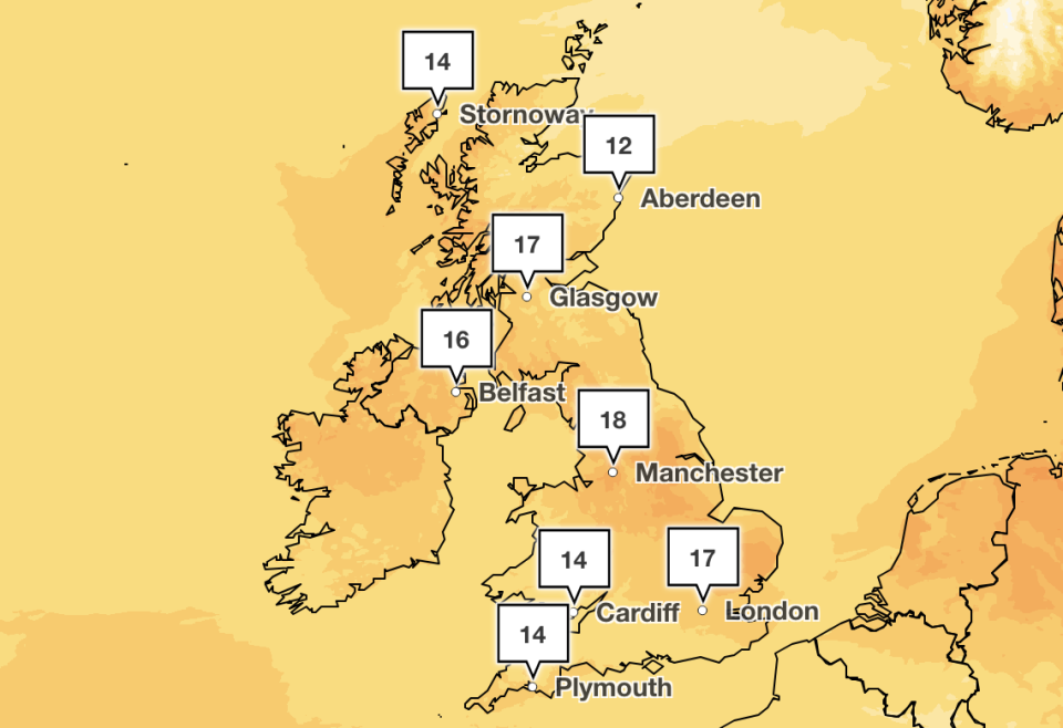
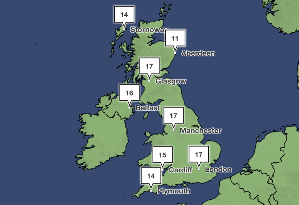
Temperatures should reach past 20C later this week as some warm weather finally breaks out across the UK.
The Met Office said the sunshine will eventually arrive in the coming days after a month of April showers, with 22C expected on Thursday.
Its forecasters say they don’t yet have a clear picture of what the early May bank holiday weekend will bring, but the higher temperatures are expected to remain.
Met Office spokesperson Andrea Bishop told Yahoo News UK: “Although the weather is likely to remain rather mixed during the week ahead with low pressure never too far away, it is warming up compared to the past couple of weeks.
“Temperatures really do depend on breaks in the cloud but in the sunshine, we should see temperatures into the late teens or early 20s, with Thursday looking at the moment, to be the peak.”
The south-east of England is expected to see the highest temperatures later this week, while the recent wet weather won’t disappear completely, with the east coast of Scotland expected to endure more rain.
Amy Bokota, senior meteorologist at the Met Office, said: “It might not be the sort of glorious sort of heatwave that we’re hoping for, but there probably will be some more pleasant and warmer weather for some people as we head towards the end of the week.”
There will be some big temperature contrasts this week, depending on the amount of cloud cover you have 📈📉
Where the sun appears, temperatures will climb into the low twenties. Where it remains cloudy and breezy, it will struggle to reach the mid-teens 🌤️☁️ pic.twitter.com/KT3yAlFMlh
— Met Office (@metoffice) April 29, 2024
In its long range forecast, the Met Office indicated that Britons could enjoy some warm weather over the bank holiday weekend.
It said: “During the weekend, northern parts of the UK are likely to be predominantly dry, while areas of rain or showers, perhaps heavy and thundery, clear erratically from the south to usher in a spell of drier weather here too.
“There is likely to be a fair amount of low cloud in the east at times, with spells of coastal fog, but also temperatures generally above average for the time of year.”
So far this month, the maximum temperature recorded has been 21.8C in Writtle, Essex, on 13 April, with a low of -6.3C recorded in Shap, Cumbria, on 26 April. The average temperature for the UK this month has been 8.4C.
Yahoo breaks down what the weather will be like for each region of the UK, according to the Met Office.
London and the South East
A good deal of sunshine throughout the day, perhaps turning cloudier in the northwest of the region by the afternoon. Staying dry and breezy. Mild. Maximum temperature 16°C.
A cloudy start to the night in the far west of the region, becoming clear, meanwhile skies remaining clear elsewhere. Dry throughout the night and staying breezy. Minimum temperature 3 °C.
A sunny start to Tuesday with cloud and heavy showers spreading up from the south during the afternoon and evening. Potential for thundery outbreaks. Rather mild. Maximum temperature 17°C.
Fog and low cloud becoming confined to the coast by day through the period. A threat of heavy and thundery rain spreading north on Wednesday and Friday. Rather warm.

South West
Scattered showers across Devon and Cornwall with rain persisting through this afternoon. Eastern parts of the region turning cloudier but remaining largely dry. Brisk southerly winds and windy on southern coasts. Maximum temperature 14°C.
Staying similar overnight with some rain edging east into Somerset and Dorset and heavier rain possibly developing in Cornwall later. Staying rather windy in the west. Minimum temperature 7°C.
Outbreaks of rain edging east through Tuesday with sunnier skies and isolated showers following to Cornwall. Winds easing and feeling a bit warmer. Maximum temperature 15°C.
Turning drier as we move into May but some rain remains possible. Feeling warmer than recently with spells of sunshine. Temperatures often somewhat above average but also breezy at times.
Midlands
Staying largely cloudy this afternoon. A few showers are possible at times, these mostly in the west. Feeling warmer than yesterday despite brisk southerly winds. Maximum temperature 15°C.
Mostly dry this evening and overnight with clear spells although the odd shower is possible. Minimum temperature 7°C.
Largely dry and fine on Tuesday with spells of sunshine at times. Breezy but feeling warmer than on Monday. Maximum temperature 17°C.
Mostly dry as we move into May but showers remain possible. Feeling warmer than of late with spells of sunshine. Temperatures becoming generally above average but also breezy at times.
North East
Often cloudy with any brighter spells towards the coast. Outbreaks of showery rain, potentially heavy over western hills. Blustery southerly winds, near gale force over the Pennines. Maximum temperature 14°C.
Staying cloudy overnight with further outbreaks of rain, especially over western hills. Staying breezy. Becoming brighter from the south towards the morning. Minimum temperature 7°C.
Sunshine developing from the south through Tuesday morning and becoming largely dry aside from a few isolated showers in the afternoon. Rather warm. Staying breezy. Maximum temperature 18°C.
Largely cloudy but mild with outbreaks of rain along the coast Wednesday. Mist and fog likely lingering along the coast with the best chance of sunshine inland Thursday and Friday.
North West
Often wet across Cumbria today with persistent and heavy periods of rain over the Fells. Otherwise largely dry at first but scattered showers breaking out. Brisk southerly winds, strong on coasts, but nonetheless feeling somewhat warmer than over the weekend. Maximum temperature 14°C.
Further showery rain this evening but turning drier overnight, although the odd shower remains possible. Winds easing a little overnight. Minimum temperature 7°C.
Rather cloudy at first on Tuesday but brightening up with sunny periods. Perhaps remaining cloudier on western coasts. Breezy but feeling warm in any sunshine. Maximum temperature 17°C.
Turning drier as we move into May but showers remain possible. Feeling warmer than of late with spells of sunshine. Temperatures often somewhat above average but also breezy at times.
Scotland
A dry start with bright or sunny spells, but rain soon reaching the Central Belt this morning will extend north to all areas by midday, the rain turning heavy in places, before it turns brighter and showery later. Maximum temperature 13°C.
A bright start on Tuesday with some sunshine then clouding over for a time with some patchy rain. The sun returning later and becoming warm inland. Maximum temperature 17°C.
Cloudier on Wednesday, patchy rain in east, brighter in west. Thursday will be dry, mainly cloudy but perhaps sunnier in far west. More widely sunny on Friday, warmer.
Northern Ireland
Generally brighter in the afternoon, but with scattered and at times heavy showers. Maximum temperature 14°C.
A mainly dry evening and night with isolated showers dying out and some longer clear spells. Then it will cloud over towards morning with some heavy showers. Minimum temperature 7°C.
A cloudy morning on Tuesday with some heavy showers, some prolonged. Then brighter in afternoon with sunny intervals and more isolated showers. Maximum temperature 14°C.
Wednesday mainly dry with sunny spells, some showers in evening. Then Thursday and Friday will be dry, sunny and warm.
Although the weather is likely to remain rather mixed during the week ahead, with low pressure never too far away from the UK, temperatures are likely to rise 🌡️📈
From Wednesday temperatures could reach around 20 °C in a few places pic.twitter.com/RYhm0Yh3j0
— Met Office (@metoffice) April 28, 2024
Wales
Often cloudy with occasional bright or sunny intervals in the east during the morning. Scattered showers first thing with more general rain developing through the day, heavy at times in the south and west. Windy, particularly on western coasts. Maximum temperature 15°C.
Further rain at times this evening and overnight. Some heavier bursts are likely, mainly in the south and west and over higher ground. Drier spells developing in the northeast. Breezy. Minimum temperature 7°C.
Often cloudy with showery rain on Tuesday, persistent and heavy at times. Perhaps turning sunnier by the evening in the west. Windy in the morning though winds easing through the afternoon. Maximum temperature 15°C.
Turning drier as we move into May but some rain remains possible. Feeling warmer than recently with spells of sunshine. Temperatures often somewhat above average but also breezy at times.


