


Get the free Morning Headlines email for news from our reporters across the world
Sign up to our free Morning Headlines email
Weather warnings and dozens of flood alerts have been issued across swathes of England and northern Wales, as thunderstorms are set to put a dampener on the May bank holiday weekend.
After a mixed week, the long weekend began with warmer weather and spells of sunshine, with temperatures expected to rise to 22C in London on Saturday as Manchester’s major rival football clubs battle for the FA Cup at Wembley and the general election campaign gets into full swing.
However, bands of rain along England’s east coast and in Cornwall are expected to start moving northwards across the country on Saturday evening, bringing heavy and thundery showers.
And the stormy conditions are set to intensify on Sunday, prompting the Met Office to issue a vast weather warning stretching nearly from Middlesbrough and Sedbergh to Milton Keynes, ranging from England’s east to west coast and encroaching into northwestern Wales.
That alert will be in force from midday until 8pm on Sunday, with Met Office forecasters warning that the heavy showers and thunderstorms may cause flooding and disruption.
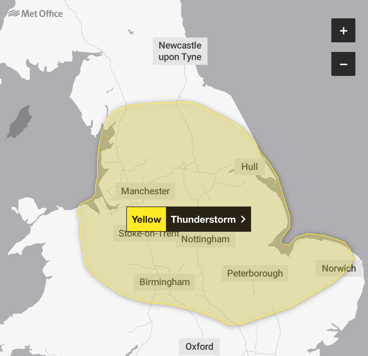
Sudden flooding could create difficult driving conditions, or even lead to communities being cut off by road closures, with a small chance of homes and businesses becoming rapidly flooded or damaged by lighting strikes, forecasters said.
Trains and bus services could face cancellations and delays, with the chance of power cuts and other services to some homes and businesses being lost, the Met Office warned.
As much as 20mm to 30mm could fall over a few hours and there may be some frequent hail and lightning strikes.
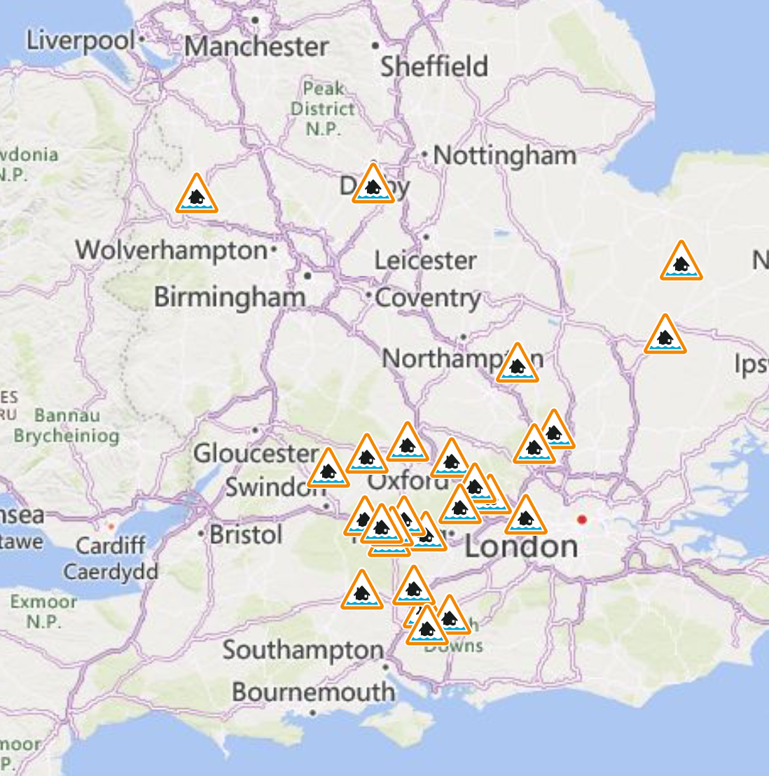
The Environment Agency has issued 26 flood alerts, meaning flooding is possible – mostly centred in southern England to the west of the capital, but also near Derby and Shrewsbury.
But the picture will brighten somewhat on Monday with drier conditions possible in parts of Wales, Northern Ireland and south-west England in the afternoon. A mix of “sunshine and showers” will be the case for many on Monday, forecasters said.
Met Office meteorologist Craig Snell said: “Overall, it’s a pretty mixed picture, Saturday’s probably the best of the bunch, but there will still be some sunshine around on Sunday and Monday, but we’ll certainly be dodging downpours.
“Watch out for some thunderstorms especially across parts of northern and central England and north-east Wales too.”
MET OFFICE OUTLOOK
Saturday:
Early mist and fog clearing, leaving generally a dry and fine day. Cloudy with some sunnier interludes. The odd shower around with some longer spells of rain around North Sea coasts and later into the southwest. Warm in the sunshine.
Saturday night:
Often cloudy overnight with outbreaks of showery rain. Heavy in places, particularly in the southwest and also northern England and southern parts of Scotland. Feeling mild under cloudier skies.
Sunday:
A cloudy start with spells of rain. Turning showery into the afternoon with some sunny spells in between any showers, though these heavy and thundery at times. Temperatures around average.
Outlook for Monday to Wednesday:
An unsettled start to the week with sunshine and showers for bank holiday Monday. Cloudy with longer spells of rain on Tuesday and further showers on Wednesday. Feeling cooler.
Additional reporting by PA


