
The Met Office has forecasted that Brits will face a Bank Holiday Monday washout today, as “unsettled conditions” are expected to sweep through the UK with heavy rain at times
The Bank Holiday weekend is set to end on a washout as “unsettled conditions” are predicted across huge swathes of the UK.
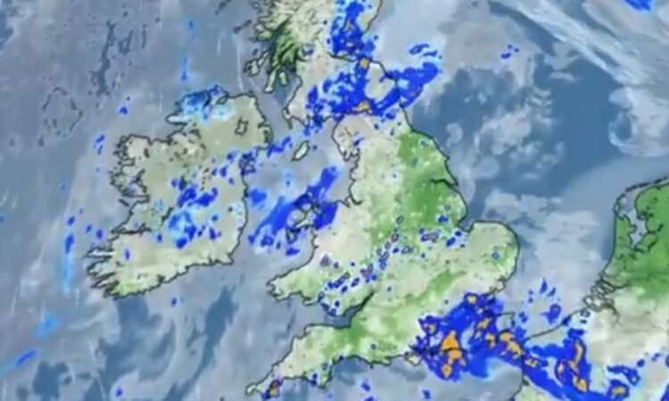
After a glorious day of sunshine yesterday, the Met Office forecast that today will see “rather unsettled conditions” as low-pressure systems remain hovered over the British Isles. In a video graphic uploaded to Twitter, the caption reads: “Outbreaks of rain, heavy at times, across southeast England. Cloudier in the north with patchy rain. Sunny spells elsewhere with scattered showers.”
One silver lining is that despite the grim conditions, it will still be warm – with highs of 19C in the northeast, with 17 and 18C predicted for many southern parts. It will be far cooler in Northern Ireland and eastern Scotland where the temperatures will peak at 11C.
Though the next couple of days look mixed, the longer-range forecast looks brighter as a mini-heatwave is expected to hit within days. Weather maps are finally turning red as the UK is expected to sizzle in 25C highs.
Brits have just emerged from one of the wettest Aprils on record since 2012 as 55 per cent more rain than average was seen in parts of the country. But within days, the forecast will be a stark contrast from that dreary month as a Ventusky weather map turns from amber to red – marking a significant surge in temperatures.
On Sunday May 12, few locations will see the mercury drop below 15C, while huge swathes of the British isles will sit around the toasty 25C mark. The warmest areas will be along the East Coast, London, and its surrounding counties. However, temperatures exceeding 20C will also be seen as far north as Scotland.
It comes after the Met Office’s long-range forecast for May 9 to 18 predicted some “very warm days” ahead, with temperatures set to be slightly above normal. The forecast reads: “There is a strong signal for high pressure across the UK at the start of this period, bringing a good deal of fine and dry weather for most areas, though with patchy mist and fog in places each morning.
“Northwestern parts of the UK are likely to be the exception to this, with more in the way of cloud and rain at times here. The high is likely to maintain its influence into the weekend before starting to weaken during the following week.
“So a continuation of fine weather through the weekend seems likely for most, before a return of less settled conditions during the following week. Temperatures are expected to be slightly above normal for early May, with some very warm days possible.”
The Met Office’s forecast was similarly told by Netweather, who said that from the middle of next week the UK will experience warm sunshine. It said: “High pressure will build through Tuesday and Wednesday, bringing warm and sunny weather to most of England and Wales and temperatures into the low 20Cs.”
Looking even further ahead from May 19 until June 2, the Met Office says that despite warm days being likely, there is a “greater chance” of unsettled weather returning. Its forecast reads: “During the longer range outlook period, there is a greater chance of unsettled weather returning across the UK. This means that spells of wet weather are likely for most, with no particular location more prone than anywhere else.
“The chances of above or below average temperatures are fairly balanced, but at this time of year this means that some warm days are likely.”
UK five-day Met Office forecast
Today:
Sunny spells and heavy showers will develop across most of the UK today, some of these heavy and slow moving with the odd rumble of thunder. Cloudier in the southeast with heavy and persistent rain. Feeling warm in any sunshine.
Tonight:
Showers and rain will gradually ease away tonight with partly cloudy skies. Patchy low cloud, mist and fog will develop in places. Turning chilly under clear spells
Tuesday:
A cloudy start, but sunny spells will develop for most through the day. However, staying largely cloudy across the north. A few showers forming in the south in the afternoon.
Outlook for Wednesday to Friday:
Largely fine and dry with variable amounts of cloud and some sunshine. Rain will move into parts of Northern Ireland and northern Scotland on Wednesday. Rather warm in the sunshine.


