
Britons expecting weather forecasts for the Bank Holiday weekend may have to go in blind after the Met Office admitted its selection of computer models were “disagreeing” over a prediction, sparking “uncertainty”.
A press release from the Met Office said there was “still some uncertainty around the exact details of the forecast”.
It continued: “The various computer models are disagreeing about the exact track an area of low pressure will take across the southern UK and therefore where will see the worst of any weather.”
But forecasters remained certain about the area of low pressure which heralded booming thunderstorms in the early hours of yesterday morning.

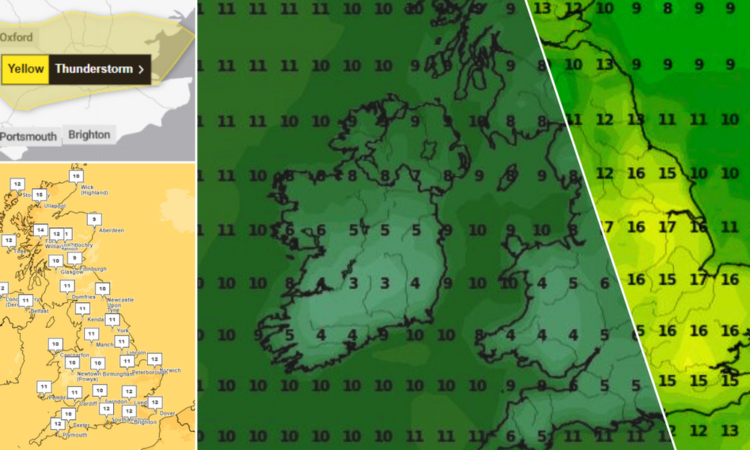
The Met Office admitted its selection of computer models were “disagreeing” over predictions for the weekend
WXCharts/Met Office
The Met Office had issued a yellow weather warning for storms in central England and parts of Wales yesterday, which finally subsided at midnight last night.
Meteorologists said today would “remain unsettled with rain or showers for some”, adding “the risk of thunderstorms continues, but the risk is lower [today] with storms fewer in number and more isolated.”
Deputy Chief Meteorologist Mark Sidaway said: “There continues to be uncertainty around the track of a low-pressure system which is expected to cross the southern UK this weekend, meaning there is some uncertainty about some of the forecast details.
“While it will remain unsettled with further showers or longer spells of rain, all areas should see some drier conditions at some point and, in any sunshine, it should feel quite warm.
MORE WEATHER NEWS:

The Met Office had issued a yellow weather warning for storms in central England and parts of Wales yesterday
PA
“But for the exact details for your area stay up to date with forecast over the coming days.”
After the Bank Holiday, the Met Office said it looked like high pressure will start to build through the second half of next week, “potentially bringing a more settled, drier, period”.
According to data from MetDesk, the vast majority of the UK won’t see temperatures rise past 12C until Tuesday evening, while people in Manchester and the North-West will be able to enjoy the relative warmth of 15C by Sunday.
Thermometers are set to stay in the mid-teens for the next two weekends, but by midday on Monday, May 13, areas of southern England and northern Scotland will, at last, break the 20C barrier.
In the south of England, maps are set to turn yellow as air temperatures cross 21C in Surrey and Hampshire, while parts of Somerset and Wiltshire reach 20C.
Parts of Gloucestershire and East Wales, as well as areas of Scotland around Inverness, are also heading for a balmy few days, as the UK finally starts showing signs of summer.
The Met Office’s long-range forecast, which covers May 7-16, says the high pressure “will bring more in the way of dry and fine weather for most areas, although there is still a chance of some showers in places, and a risk also of some more persistent rain rounding the high into north-western parts of the country”.
The forecast adds: “A continuation of fine conditions next weekend seems likely, before a return of less settled conditions by the end of the period. Temperatures are expected to be slightly above normal for early May.”


