
BRITS will finally have a break from downpours today – but dozens of flood warnings remain in place.
It comes after the UK was hit with days of heavy rain as Storm Ciaran wreaked havoc.
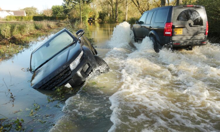
Forty warnings that flooding is likely remain in place this morning along with 150 more warnings that flooding is possible, the Environment Agency said.
The majority of warnings were along the south coast from Weymouth to Bexhill, where the Met Office warned that heavy rain was falling on saturated ground on Saturday.
There were also flood warnings near Godalming in Surrey, for the River Ouse at York and the River Waveney from Diss to Bungay in East Anglia.
Other warnings remained on the River Witham near Lincoln, the River Dene at Walton in the West Midlands and in the area of Marchington in east Staffordshire.
Natural Resources Wales had one flood warning in place on Saturday evening, with flooding expected along the River Ritec at Tenby, Pembrokeshire.
Alerts that flooding is possible have also been issued in South Pembrokeshire, in the lower Teifi catchment downstream of Llanybydder, around the River Wye and the Lower Severn in Powys, for the River Ewenny and Vale of Glamorgan west and for River Vyrnwy, River Tanat and River Cain and their tributaries.
There are warnings of possible flooding across England with only the north west and far north east unaffected. There are no active flood warnings for Scotland.
Showers will predominantly be in the west on Sunday with dry and brighter conditions in the east, and no weather warnings are currently issued.
It comes after Storm Ciaran battered the south coast and the Channel Islands with heavy rain and gusts of up to 100mph on Thursday, leaving nearly 150,000 homes without power.
Frank Saunders, chief forecaster at the Met Office, said: “After the events of this week, the forecast is moving into a period of fairly typical autumnal weather, with breezy conditions and spells of rain and showers, interspersed with some clearer and brighter periods.
“We still have warnings in the forecast, partly because the ground is already so wet but overall conditions are expected to be less impactful than we’ve seen over the last few days.
“Aside from scattered showers in the north and west of the UK, Bonfire Night (Sunday) will be largely dry and settled, although temperatures will be dipping compared with values last week.”
Schools across the UK were still shut on Friday after Storm Ciaran lashed the country.
The storm also caused a major sewage overflow and leaving thousands of families without tap water in and around Southampton.
Southern Water said: “We’re really sorry that customers are likely to experience either low pressure or a loss of water supply.
“This is due to Storm Ciarán’s unprecedented impact on the water quality and levels of the River Test, close to our Testwood Water Supply Works.
“This has made it extremely difficult for us to abstract water and treat it for drinking water, and has led to a temporary site shutdown.
“As a result, we are struggling to fill reservoirs in some areas of southern Hampshire and the Isle of Wight.
“Our teams are working around the clock to get our Testwood site back working as soon as possible as stormwater levels fall and water quality improves.”


