The UK is set for a surge in rainfall over the Easter weekend, forecasters have said – but temperatures are set to jump heading into April as Britain finally leaves winter behind.
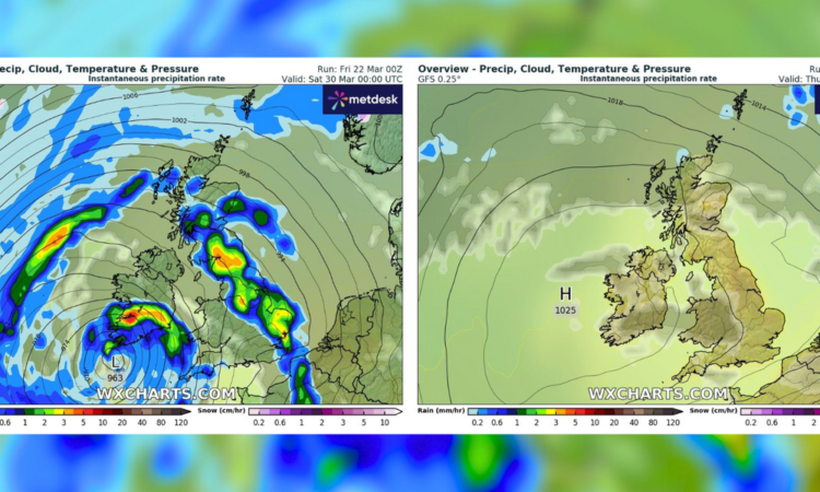
After what has been one of the wettest meteorological winters on record, multiple bands of rain are due to touch down in the UK next Friday night, according to latest data from MetDesk.
The downpour is set to linger over the country for the remainder of the Easter bank holiday weekend, with Scotland, northern and eastern England heading for the worst of the rain, but the Met Office’s long-range forecast predicts wet conditions everywhere across the land for the next two weeks.
The forecast says: “Through the bank holiday weekend and into the following week, unsettled or changeable weather remains the most likely outcome.

MetDesk data shows Easter’s bands of rain subsiding into the week – but, not before the bank holiday ends
WXCharts
“All areas are likely to see further rain or showers at times, with some drier spells in between. Wet weather will tend to favour the southwest, while northern parts remain a bit drier on average.”
Downpours and storms over the last few months have caused significant flooding and disruption – in February alone, England saw almost 200 flood alerts and 57 flood warnings.
Fortunately, as April rolls around, the Easter showers are set to subside in favour of some positively balmy dryness and warmth.
By Thursday, April 4, practically all of mainland Great Britain and Northern Ireland is set for temperatures in the high teens, with Yorkshire experiencing highs of 19C.
MORE WEATHER NEWS:

The UK and Ireland can look forward to temperatures in the high teens in the week following Easter
WXCharts
The unseasonably warm weather won’t come in time for the bank holiday weekend, despite Spring officially having begun this week.
MetDesk data shows highs of a paltry one degree on Good Friday in western Scotland, while England, Wales and Northern Ireland will have to make do with temperatures ranging from 3-5C.
The rainfall slated for Easter will only add to a record 18 months of wet weather in the UK, with England experiencing its highest levels of rainfall since records began in 1836.
The groundbreaking wet weather has seen farmers unable to plant crops in water-stricken fields, as well as transport networks crippled by floods, leaving climate scientists worried.
And the chilly temperatures over Easter could even herald snow, according to Nathan Rao, though he acknowledged a dusting of the white stuff would probably only hit high-altitude areas.
But bookmaker Coral has reset the odds to 2/1 from 6/1 on a White Easter – which is often more likely than a White Christmas.
But Coral spokesperson John Hill said: “With the threat of snow on the horizon this Easter, our betting suggests there is no danger of Easter eggs melting this year.”
Colder weather may, in part, be the result of a third Sudden Stratospheric Warming (SSW) event this season – caused by winds in the stratosphere slowing or changing direction, forcing lower, colder air to spill out of the Polar region.


