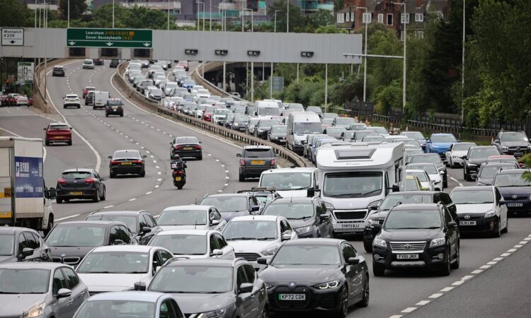
Bank Holiday travel chaos paralyses the UK as rail network is crippled by cancelled trains, three million drivers hit the roads and families face two-hour ferry queues at the Port of Dover

British families faced Bank Holiday travel chaos today as trains were suspended, ferry passengers faced two-hour waits and more than three million drivers hit the roads.
Avanti West Coast advised customers not to travel to or from London Euston station after a major signal failure blocked all lines between the capital and Milton Keynes.
The chaos came on top of pre-planned Network Rail engineering work on the West Coast Main Line route resulting in longer journeys between London and Scotland.
This included bus replacements between Preston and Carlisle, and Carlisle to Glasgow or Edinburgh; and an amended service between Stafford and Crewe.
In London, there was disruption on the Elizabeth line between Paddington and Southall due to a speed restriction imposed over defective track; while Overground trains faced delays due to an object becoming stuck in overhead power cables.
It was also a busy day to drive, with the RAC estimating 3.4million motorists will be on the roads today on the final day of the three-day Bank Holiday weekend. The worst period for congestion today is expected to be between 11am and 2pm.
Click here to resize this module
In addition, DFDS Ferries warned customers of a ‘busy day’ at the Port of Dover in Kent and told them to allow 120 minutes to complete border control and check-in.
And thousands of Britons were stuck in queues for hours at Birmingham Airport amid ‘shambolic’ and ‘terrible’ scenes while families fly away on half-term holidays.
Avanti West Coast said today: ‘Due to a severe signalling failure in the Cheddington area, we are advising customers not to travel to or from London Euston.’
But one angry passenger tweeted the operator to say: ‘Thanks again for another disastrous journey from the North to London – I don’t how know you manage it!’
Another said: ‘Avanti West Coast cancelling a load of trains again last minute. Absolute shambles of a company, not fit for purpose.’
And a third added: ‘When you make a point of booking yourself onto an early train only to be told there will be delays.’
Click here to resize this module
All lines between Milton Keynes and Watford Junction were closed for a period this morning. While they have since reopened, travellers were still being warned of cancellations this afternoon.
Passengers were told tickets dated for today could be used tomorrow – with travel on different routes between London, the Midlands and North West also encouraged after ticket acceptance was put in place with other operators.
But there were also problems on Thameslink trains due to a signalling fault between St Albans and West Hampstead; and on Transport for Wales between Shrewsbury and Wrexham due to an emergency incident.
Further north on ScotRail, there was disruption between Edinburgh and Helensburgh Central and between Airdrie and Balloch due to a fault on a train at Airdrie.
It comes as parts of Britain faced a washout Bank Holiday Monday today with up to an inch of rain expected along with warnings of flash flooding and thunderstorms.
The Met Office said most areas of the UK will see a mixture of sunny spells and scattered showers at the start of what is the last week of meteorological spring.
Click here to resize this module
But slow-moving heavy showers and thunderstorms could cause flooding and travel disruption in Scotland where 1.6in (40mm) of rain is set to fall in just a few hours.
Temperatures will be around average for this time of year with maximums of 19C (66F) today, although forecasters said it would feel fresh under any cloud or rain.
The Met Office said low pressure would remain slow-moving across the British Isles today, maintaining a changeable theme that was also seen over the weekend.
However it will be feeling cooler today than over the weekend – which saw highs of 21.6C (70.9F) in London – with a brisk breeze in the South and West.
The Met Office has issued a yellow thunderstorm warning for northern and eastern areas of mainland Scotland from 11am until 10pm today.
Greg Dewhurst, meteorologist at the Met Office, said: ‘There are some subtle differences – I think generally, England and Wales will see less frequent and less heavy showers compared to Sunday, so there should be some longer, drier spells in between.
Click here to resize this module
‘But it is worth, if people are heading out, having a brolly and raincoat as there is a chance almost anywhere of having a shower, true for Northern Ireland too, actually.’
Thicker cloud is expected move in across south-west England by the end of the day with the chance of patchy rain, but any lingering showers should fade as the evening progresses.
Another frontal system will move in tomorrow from the West and rain will spread across many areas following a bright start in the east, with temperatures staying around average.
By Wednesday, low pressure will continue to dominate the weather with many areas seeing a mix of sunshine and showers, which could be heavy and thundery in places.
This low pressure will then begin to move away to the east on Thursday, but it will again be sunny and wet for many areas – although western areas could turn drier.
Eastern areas will still be under the influence of low pressure by Friday which will continue the showery theme, but western parts will likely see a drier day.
The Outer Hebrides and the Isle of Skye had a separate warning for rain in place from midnight to 9am this morning but it is not expected to be as heavy.
The Environment Agency has issued 22 flood alerts for England, all in southern areas.


